

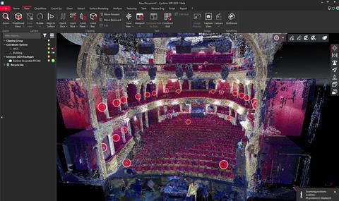
Cyclone 3DR can automatically identify individual objects, edit them and create digital assets from a LiDAR scan
Leica Geosystems, part of Hexagon, has launched Cyclone 3DR, a suite of AI-powered tools for use with LiDAR scans.
With Cyclone 3DR, production can take a LiDAR capture of a real-world location and use proprietary AI-powered tools to automatically identify individual objects, edit or remove them and create digital assets, within the scan itself. The end results can be exported in any file type to create a library of assets.
LiDAR scans are currently used for building immersive VR locations, animating real-world environments and supporting pre- and post-production.
Users can pair Cyclone 3DR with a NVIDIA RTX PRO GPU to access the AI-powered features, beginning with AI Classification. LiDAR scans are typically composed of millions or billions of small points of data, collectively grouped into a point cloud dataset. That gives scans realism and depth in a 3D model, but it also makes it difficult to edit individual objects directly. The AI Classification tool identifies the points and classify groups into a recognizable asset.

Follow AI Media News on Linkedin here, and X here, and sign up to its weekly newsletter here.
From there, users can work directly with the object to clean it up, edit it or remove it completely using the new AI Segmenter tool. The object can then be added to a library and redeployed later in a future 3D project. Users can also choose to use the internal automated process for quick results, or create custom scripts and filters that fit with existing workflows.
There are six AI-powered models to choose from, four tailored for commercial use cases — heavy construction, indoor construction sites, industrial plants and roads — while two others cover more general indoor and outdoor environments. Each model has been trained on ethically sourced datasets, including point clouds, 2D images, and 3D models relevant to its environment. In addition, users can choose to continue working directly with the point cloud data or opt to use Cyclone 3DR’s advanced meshing algorithms to generate high-quality meshes, complete with additional data including volume calculations, deviation analysis and more.
“LiDAR scans offer the best possible way to create realistic digital environments, but their quality and complexity can make them tricky to use without the proper tools,” said Yannick Stenger, product manager at Hexagon. “Our ongoing research into AI has made it possible to do things most never even considered possible, and in doing so, we can bring this technology to a much wider audience than ever before.”


No comments yet